Evacuations in the burn areas of the Thomas Fire in Ventura and Santa Barbara counties were lifted Thursday as a powerful spring storm continued to bring strong showers in some coastal areas.
A flash flood advisory was issued for western Santa Barbara County until 10 p.m. because of brief heavy downpours and a slight chance of thunderstorms in that area, the National Weather Service (NWS) tweeted.
During the evening, a mudslide was reported along the 192 Freeway near Toro Canyon. No injuries were reported and nearby homes were determined to be safe, authorities said.
A mudslide has been reported on Hwy 192 near Toro Canyon. Barricades in place and CHP responding. Residents in the area are able to pass by using a single lane. All homes in the area have been determined as safe. Exercise caution when driving on wet roads. #SantaBarbaraCounty
— Santa Barbara County (@countyofsb) March 23, 2018
Flash flood warnings and advisories issued in Ventura County Thursday morning were canceled by the early evening but then reissued later that same night. NWS officials announced flash flood warnings were in effect for Ventura County and burn areas of the Thomas Fire shortly after 10 p.m.
An automated gauge at El Rio (near Oxnard) reported 0.64 inches of rain in 1 hour. Flood advisory in effect for Ventura County. #CAstorm #LArain #cawx
— NWS Los Angeles (@NWSLosAngeles) March 23, 2018
Automated gauge at Fillmore reported 0.27 inches in 10 minutes between 952 and 1002 pm, at eastern end of #ThomasFire burn scar. #CAstorm #cawx #LArain
— NWS Los Angeles (@NWSLosAngeles) March 23, 2018
At 6:30 p.m. showers continued, but the heaviest showers were in Santa Barbara County.
By 10 a.m., the storm was increasing in intensity, with some parts of Southern California noting precipitation rates of at least a half-inch per hour. By 3:25 p.m. Thursday, officials had issued a flash flood advisory for the areas affected by the Thomas Fire in western Ventura and eastern Santa Barbara counties, according to the National Weather Service. Flash flood warnings and watches had previously been in place.
At 3 p.m. brief and heavy showers were moving across the burn areas, the National Weather Service tweeted. Rainfall rates ranged between .25 and .45 inches per hour in the foothills of Santa Barbara and Ventura counties. The rain rate is expected to result in additional water in creeks and minor debris flows in the burn areas.
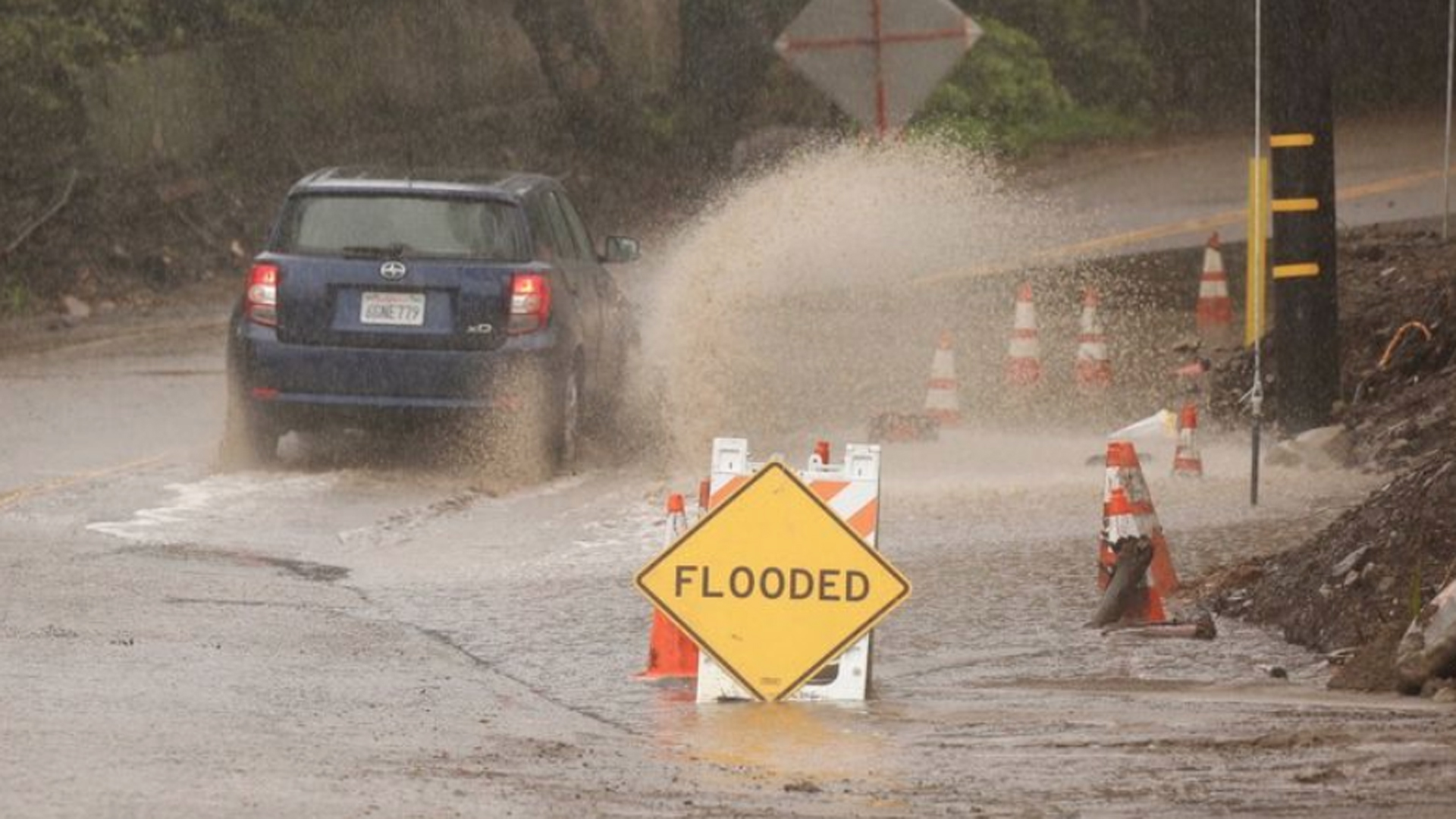
Several area roads were closed midday due to flooding, though it didn’t appear any structures were immediately damaged or threatened.
Meanwhile, weather officials warned of heavy showers and possible flooding in areas of eastern Ventura County and western Los Angeles County.
Flood Advisory for eastern VTU County & Heavy showers were moving into eastern Ventura County and the western valleys and mountains of L.A. County. Some local roadway flooding possible and possible minor debris flows for Rye, Creek and La Tuna Burn areas. #CAstorm #LArain #cawx pic.twitter.com/B7P37ARcDb
— NWS Los Angeles (@NWSLosAngeles) March 23, 2018
Officials noted in an earlier news release that the storm’s intensity was expected to pick up in the county “significantly” Thursday morning, with forecasts predicting rainfall rates of up to 1 inches an hour and increasing in excess of that during thunderstorms.
“The present wave of this storm is much stronger and more dangerous than what we have experienced over the last 24 hours,” Rob Lewin, the director of the Santa Barbara County Office of Emergency Management, warned in the release.
In neighboring Ventura County, widespread moderate to locally heavy rain was reported around 8:20 a.m. bringing more than a half-inch of rain per hour as it shifted toward Los Angeles County, according to the weather service.
48-hour rainfall totals across southwestern CA ending ending at 130 PM PDT today. (Courtesy of Ventura County Watershed Protection District.) #cawx #SoCal #LARain #LAWeather pic.twitter.com/J5rvflRnlA
— NWS Los Angeles (@NWSLosAngeles) March 22, 2018
The intense downpours triggered a flash flood warning for parts of the Thomas Fire burn area around Ojai, where “significant” mud and debris flows are “likely” until 11 a.m., forecasters said.
Heavier rain also began falling around 9:10 a.m. northwest of Santa Barbara, in the Santa Ynez Valley, prompting the weather service to issue a flash flood warning for the Sherpa and Whittier fire burn areas.
By 10:30 a.m., the storm had brought about 2 1/2 inches of rain to Montecito and 2.74 inches to Santa Barbara. County precipitation totals were generally higher in the mountain and foothill areas, with rainfall totals well climbing above 4 inches in the Refugio Pass and well above 3 inches in other parts.
Likewise, Ventura County also reported generally higher rainfall totals of 3 inches or more in the mountain areas, including Rose Valley which had recieved 4.13 inches by Thursday morning.
#Flooding as Reeves Creek flows over McNeil Road in #Ojai. pic.twitter.com/ww4uKx5wDF
— luis sinco (@luissinco) March 22, 2018
Day one of the storm brought record rainfall, but little damage, to Southern California on Wednesday. The City of Santa Barbara in Santa Barbara County received 1.85 inches of rain, breaking the previous record of .76 in 2017.
In Ventura County, Oxnard received 1.83 inches of rain and Camarillo saw 1.68 inches, both topping records of 1.30 inches back in 1937.
The City of Montecito, in Santa Barbara County, saw just over 2 inches of rain as of about 2 a.m. Thursday, according to the National Weather Service.
Montecito residents are among the roughly 30,000 under mandatory evacuation orders in Santa Barbara County. Displaced residents can go to the Red Cross Evacuation Center at the Earl Warren Showgrounds in Santa Barbara, at 3400 Calle Real.
Rain water from the mountains above Montecito funneling through a debris basin and shooting out like a geyser. #SantaBarbaraCounty pic.twitter.com/drz8BjI3Xc
— Steve Kuzj (@SteveKuzj) March 22, 2018
County officials urged residents under a mandatory evacuation order, as well as the general public, to stay away from evacuated areas, but those were lifted Thursday afternoon.
“This is a very serious situation,” Lewin said. “We all need to stay safe by following the directions of our public safety leaders. Stay out of evacuation areas. Exercise extreme caution when driving.”
Officials were concerned about massive mudslides in the burn areas of the Thomas Fire, which charred about 281,900 acres in Ventura and Santa Barbara counties, becoming California’s largest fire in modern history.
Twenty-one people died and two others remain missing after flash floods crashed through homes in a Montecito neighborhood back in January.
Forecasters are expecting another 2 to 4 inches of rain for the foothill and mountain areas on Thursday.
During “high intensity” times, between a half-inch to one-inch per hour could fall.
Mandatory and voluntary evacuation orders have also been issued for some Ventura County residents but they were lifted about 4 p.m. Thursday.
Route 33 near Fairview drive just east of Ojai was already closed Thursday morning due to a mudslide.
Forecasters are calling for a slight chance of thunderstorms as the storm continues into Thursday. The “last hurrah” of the storm is Thursday afternoon and evening, the weather service reported.
KTLA’s Cindy Von Quednow contributed to this story.


